
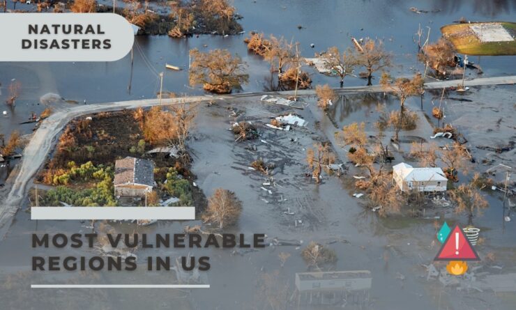
Natural disasters are a common occurrence in the United States, with the country experiencing a wide range of calamities including earthquakes, wildfires, floods, hurricanes, tornadoes, droughts, landslides, tsunamis, and volcanic eruptions.
These disasters not only cause significant damage to property and infrastructure, but they also pose a serious threat to human life.
In this article, we will delve into the various types of natural disasters that occur in the US, the regions most vulnerable to each type of disaster, and the importance of disaster preparedness.
We will also look at some of the major disasters that have occurred in the past and the lessons we can learn from them.
Types of Natural Disasters and Their Frequency
The United States experiences a wide range of natural disasters due to its vast size and diverse geographical features. Some of the most common types of natural disasters in the US include:
- Earthquakes: The US is one of the most earthquake-prone countries in the world, with the state of California being particularly susceptible due to its location along the San Andreas Fault. Other high-risk areas include Alaska, Hawaii, Nevada, and the Pacific Northwest.
- Wildfires: Wildfires are common in many parts of the US, particularly in the western states. California, Colorado, and Arizona are among the states most affected by wildfires.
- Floods: Flooding is the most common and widespread natural disaster in the US. Areas along the Mississippi River, as well as the Gulf Coast and Atlantic Coast states, are particularly vulnerable to flooding.
- Hurricanes: The Atlantic and Gulf Coast states are most at risk of hurricanes. States like Florida, Texas, and North Carolina often bear the brunt of these powerful storms.
- Tornadoes: The US experiences more tornadoes than any other country. The area known as Tornado Alley, which includes states like Texas, Oklahoma, Kansas, and Nebraska, is particularly prone to tornadoes.
- Droughts: Droughts are a common occurrence in many parts of the US, particularly in the Southwest and Great Plains regions.
- Landslides: Landslides are common in areas with steep slopes, such as the Appalachian and Rocky Mountains. The Pacific Northwest is also prone to landslides due to its heavy rainfall.
- Tsunamis: While less common than other types of disasters, tsunamis pose a significant risk to coastal areas, particularly in Alaska and the Pacific Northwest.
- Volcanic Eruptions: The US has several active volcanoes, most of which are located in Alaska and the Pacific Northwest.
Regions Most Vulnerable to Each Type of Disaster
The risk of natural disasters varies greatly across the US due to differences in geography, climate, and other factors. Here are some of the regions most vulnerable to each type of disaster:
- Earthquakes: The West Coast, particularly California, is the most earthquake-prone region in the US. Other high-risk areas include Alaska, the Pacific Northwest, and the New Madrid Seismic Zone in the central US.
- Wildfires: The western states, particularly California, Colorado, and Arizona, are most at risk of wildfires.
- Floods: The Mississippi River Basin, the Gulf Coast, and the Atlantic Coast are among the regions most vulnerable to flooding.
- Hurricanes: The Atlantic and Gulf Coast states are most at risk of hurricanes.
- Tornadoes: Tornado Alley, which includes parts of Texas, Oklahoma, Kansas, and Nebraska, is the region most prone to tornadoes.
Case Studies of Major Disasters in the Past
The Great Galveston Hurricane (1900)
The Great Galveston Hurricane, which made landfall on September 8, 1900, is the deadliest natural disaster in U.S. history.
The Category 4 storm, with winds of up to 145 mph, hit the island city of Galveston, Texas, and resulted in an estimated 8,000 to 12,000 deaths. The city was decimated, with entire neighborhoods being swept away by the storm surge.
The 1906 San Francisco Earthquake
On April 18, 1906, a major earthquake struck San Francisco and the coast of Northern California. With an estimated magnitude of 7.9, it remains one of the strongest earthquakes in U.S. history.
The quake and its subsequent fires killed an estimated 3,000 people and caused widespread devastation, with about 80% of San Francisco destroyed.
The Dust Bowl (1930s)
The Dust Bowl was a severe environmental disaster that hit the Midwest in the 1930s. A combination of severe drought and poor land management practices led to widespread soil erosion.
Massive dust storms, or “black blizzards,” caused extensive damage to homes and farms, leading to the displacement of hundreds of thousands of people.
Hurricane Katrina (2005)
Hurricane Katrina is one of the most devastating hurricanes in U.S. history. Making landfall near Buras-Triumph, Louisiana, on August 29, 2005, as a Category 3 hurricane, Katrina caused widespread devastation along the Gulf Coast from Florida to Texas.
The storm surge led to breaches in the levee system that protected New Orleans from Lake Pontchartrain, causing 80% of the city to flood. Katrina resulted in over 1,200 deaths and an estimated $125 billion in damage, making it one of the costliest natural disasters in U.S. history.
Earthquakes in the US: A Deep Dive into Seismic Activity
Earthquakes are a common natural disaster in the United States, with thousands occurring each year. These seismic events are caused by the movement of the Earth’s tectonic plates.
The United States is particularly prone to earthquakes due to its location along several major fault lines, including the San Andreas Fault in California and the New Madrid Seismic Zone in the central United States.
The science behind earthquakes
Earthquakes occur when stress within the Earth’s crust is released, causing seismic waves to radiate from the earthquake’s epicenter.
These waves can cause the ground to shake, often resulting in significant damage to infrastructure and posing a risk to human life.
The magnitude of an earthquake is measured using the Richter scale, with earthquakes above a magnitude of 7 considered to be major earthquakes.
Mapping regions in US
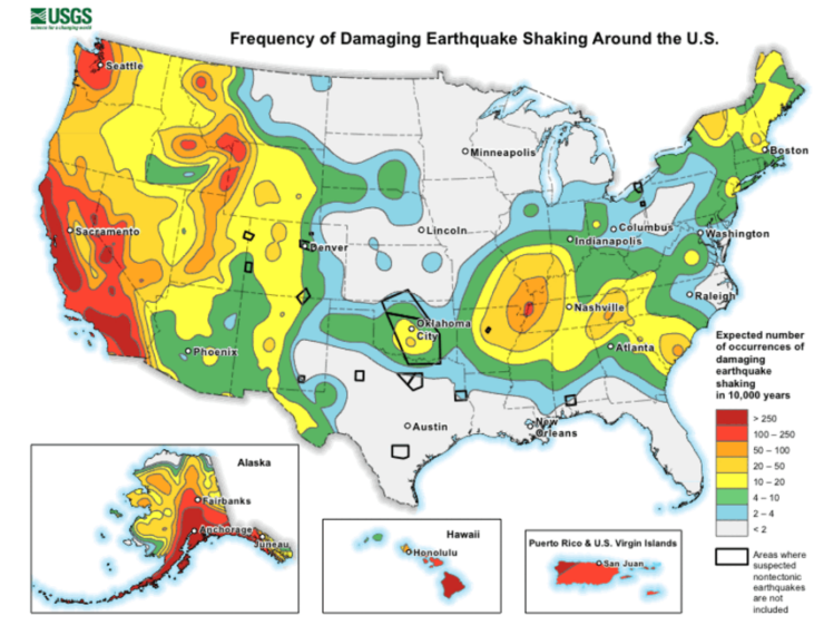
The United States Geological Survey (USGS) has identified several regions in the US that are particularly prone to earthquakes.
These include the West Coast, the Intermountain West, and parts of the central and eastern US. California is the most earthquake-prone state, with the San Andreas Fault posing a significant risk.
Other high-risk areas include the Cascadia Subduction Zone in the Pacific Northwest, and the New Madrid Seismic Zone in the central US.
The economic and human impact
The economic and human impact of earthquakes can be devastating. Earthquakes can cause significant damage to infrastructure, including buildings, roads, and power lines, often resulting in costly repairs.
They can also cause injury or loss of life, particularly in areas that are not prepared for such events. In addition to the immediate damage, earthquakes can also have long-term economic impacts, including the cost of rebuilding and potential loss of tourism.
Case study: The 1906 San Francisco earthquake
The 1906 San Francisco earthquake is one of the most significant earthquakes in US history. With an estimated magnitude of 7.9, it resulted in widespread destruction across the city and was felt as far away as Oregon, Nevada, and Los Angeles.
The earthquake and subsequent fires resulted in an estimated 3,000 deaths and caused $400 million in property damage – equivalent to over $10 billion in today’s dollars.
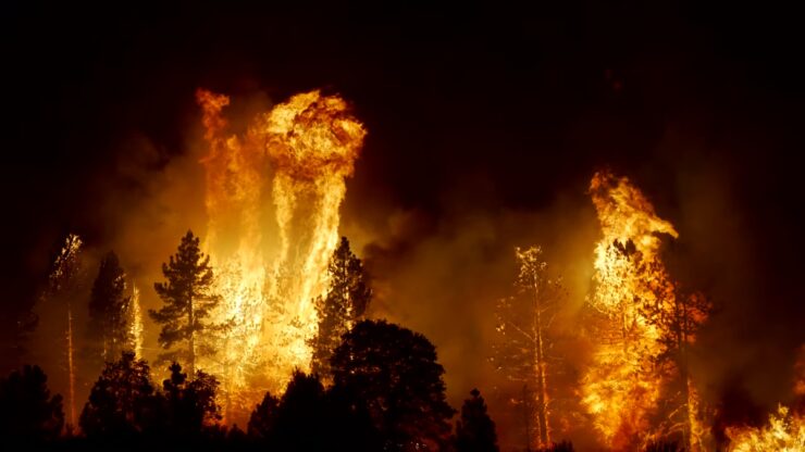
Wildfires in the US: A Burning Issue
Wildfires, also known as forest fires, have been a recurring phenomenon in the United States, causing significant damage to the environment, property, and human lives.
These fires are uncontrolled and rapidly spreading, often fueled by vegetation, wind, and topography. They can occur anywhere but are common in the forested areas of the United States where heat and drought create ideal conditions.
Causes and Effects
Wildfires can be caused by both natural and human factors. Natural causes include lightning and volcanic eruptions, while human causes encompass campfires left unattended, the burning of debris, equipment use and malfunctions, negligently discarded cigarettes, and intentional acts of arson.
According to the National Park Service, nearly 85% of wildland fires in the United States are caused by humans[^1^].
The effects of wildfires are far-reaching. They lead to the loss of human lives and property, damage to the environment, and significant economic costs.
Wildfires also contribute to climate change by releasing large amounts of carbon dioxide into the atmosphere. However, they also play a crucial role in ecosystems by helping to regenerate forests and other wildlands.
Regions Most at Risk
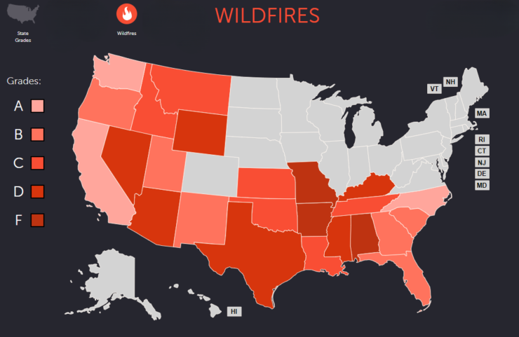
The regions most at risk of wildfires in the United States are primarily located in the West, particularly in California, Colorado, and Arizona.
These areas are prone to wildfires due to their dry climate, abundant vegetation, and frequent lightning storms.
The risk of wildfires is also increasing in other parts of the country due to factors such as climate change and human activities.
The Economic and Environmental Impact of Wildfires
The economic impact of wildfires is substantial, including the costs of fire suppression, the loss of timber and other natural resources, property damage, and the effects on tourism and recreation.
The total cost of wildfires in the United States is estimated to be several billion dollars each year.
The environmental impact of wildfires is also significant. They can cause soil erosion, water pollution, loss of wildlife habitat, and the release of carbon dioxide and other greenhouse gases.
However, wildfires also play a crucial role in many ecosystems by clearing out dead trees and underbrush, which can lead to new growth.
Case Study: The 2020 California Wildfires
The 2020 wildfire season in California was the largest in the state’s history, with over 4 million acres burned. The fires were fueled by a combination of extreme heat, drought, and strong winds.
They caused widespread damage to homes and infrastructure, forced thousands of people to evacuate, and resulted in significant economic losses.
The 2020 California wildfires also had a major impact on air quality, contributing to health problems for people living in the region.
Floods in the US: A Rising Concern
Floods are a common and destructive natural disaster in the United States, causing significant economic and human impact.
They can occur in a variety of ways, including excessive rainfall, a ruptured dam or levee, rapid melting of snow or ice, or even a beaver dam placed in an unfortunate location.
Coastal flooding occurs when a large storm or tsunami causes the sea to surge inland.
Introduction to Flooding
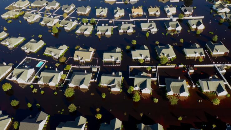
Floods are the most common and widespread of all weather-related natural disasters. In the United States, floods can occur in any region, in any season, and they can leave behind incredible devastation.
While some floods develop slowly over a period of days, flash floods—particularly common in arid areas where the ground is hard and dry—can occur quickly, even without any visible signs of rain.
It’s important to be prepared for flooding no matter where you live, but particularly if you are in a low-lying area, near water, or downstream from a dam.
Causes and Effects
Floods can be caused by a variety of factors. Heavy rainfall is the most common cause, but others include coastal storms, storm surges, and tsunamis.
Overflows from rivers and ponds, as well as the rapid accumulation of runoff from a large storm, can also lead to flooding. In the winter, heavy snowfall can eventually lead to flooding when the snow melts too quickly during the spring.
The effects of flooding can be devastating. Floods can damage or destroy infrastructure, homes, and businesses. They can also lead to loss of life and injury.
Additionally, floods can lead to other problems like landslides and mudslides. The economic impact of floods can be significant, leading to costly repairs and recovery efforts.
Mapping Flood-Prone Regions in the US
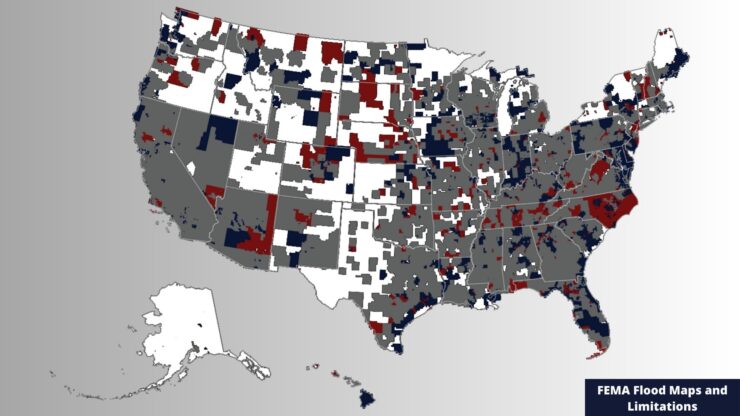
Flood risk varies across different regions of the United States. Some areas are more prone to flooding due to their geographical location and local climate conditions.
For instance, coastal areas are at risk of flooding from sea-level rise and storm surges, while regions near large rivers may experience flooding from heavy rainfall or snowmelt.
The Federal Emergency Management Agency (FEMA) provides flood maps that highlight areas at high risk of flooding.
The Economic and Human Impact
Floods can have a significant economic impact, causing billions of dollars in damages each year. These costs include damage to homes and infrastructure, loss of crops and livestock, and disruption to businesses.
The human impact can also be significant, with people losing their homes, suffering injuries, or even losing their lives.
The psychological impact of flooding can also be significant, with people experiencing stress and anxiety due to their homes and communities being damaged or destroyed.
Case Study: The 2005 Hurricane Katrina Floods
One of the most devastating floods in U.S. history occurred in 2005 when Hurricane Katrina struck the Gulf Coast.
The storm surge led to severe flooding in New Orleans and other areas, leading to over 1,200 deaths and causing about $125 billion in damages.
The response to the disaster was heavily criticized, and it highlighted the need for better disaster preparedness and response strategies.
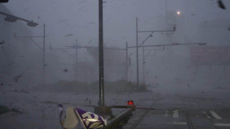
Hurricanes in the US: A Stormy Situation
Hurricanes are powerful and destructive natural disasters that pose a significant risk to coastal regions in the United States.
These storms can cause massive damage due to high winds, heavy rainfall, and storm surges that lead to flooding.
Introduction to Hurricanes in the US
Hurricanes are large, swirling storms that form over warm ocean waters. They can produce winds of 74 miles per hour or higher, and when they come onto land, they can cause immense damage due to strong winds and heavy rainfall.
The United States, particularly the Atlantic and Gulf coasts, is vulnerable to hurricanes, especially during the hurricane season that runs from June 1 to November 30 each year.
The Science Behind Hurricanes
Hurricanes form when warm, moist air over the ocean rises, creating an area of low pressure beneath it. This causes cooler air to rush in, which then warms and rises as well.
As this cycle continues, it creates a system of winds that rotates around a calm center, known as the eye of the hurricane. The storm grows in size and strength as it picks up heat and moisture from the warm ocean surface.
Once a hurricane makes landfall, it begins to lose strength as it is cut off from the warm ocean waters that fuel it.
Regions Most Vulnerable to Hurricanes
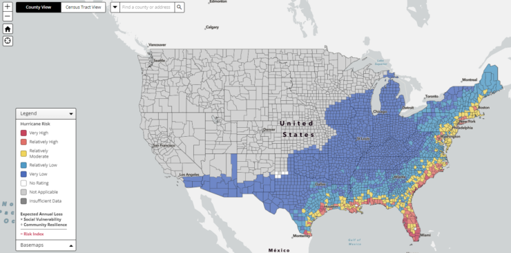
The Atlantic and Gulf coasts of the United States are particularly vulnerable to hurricanes. This includes states like Florida, Louisiana, Texas, North Carolina, and South Carolina.
These regions are at risk due to their proximity to warm ocean waters where hurricanes form. The National Hurricane Center provides updates and forecasts during the hurricane season to help these regions prepare for potential storms.
The Economic and Human Impact of Hurricanes
The economic impact of hurricanes can be immense, with damages often running into billions of dollars.
This includes damage to homes and infrastructure, as well as economic losses due to business closures and disruptions to transportation and utilities.
The human impact can also be significant, with loss of life and displacement of people being major concerns. Hurricanes can also lead to long-term issues like mental health problems and economic hardship for those affected.
Case Study: The 2017 Hurricane Harvey
One of the most devastating hurricanes in recent history was Hurricane Harvey, which struck the Gulf Coast in August 2017. Harvey was the most forceful storm to make landfall in the United States in more than a decade.
The storm drenched the Houston area, with the city receiving more than 16 inches of rain in a 24-hour period. Catastrophic flooding claimed several lives, and the economic damage was estimated to be around $125 billion.
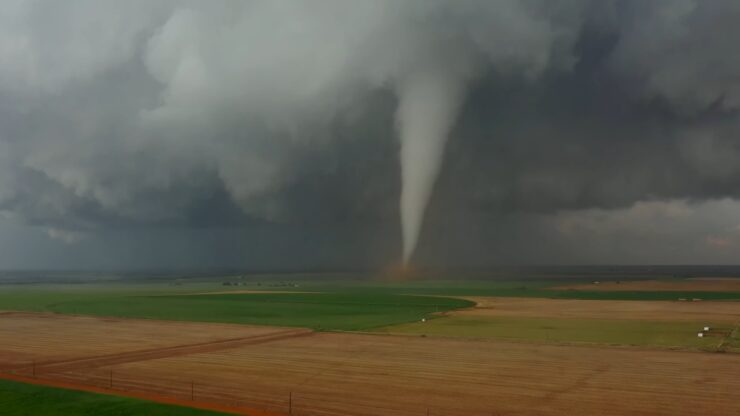
Tornadoes in the US: Twisting the Tale
Tornadoes are a common natural disaster in the United States, with about 1,200 tornadoes hitting the country each year. These violent phenomena can occur in many parts of the world, but the U.S. sees a high concentration of tornadoes due to its unique geography and weather patterns.
Tornadoes can occur at any time of year and in any state, but they are most common in the central United States, an area often referred to as “Tornado Alley.”
The science behind tornadoes
A tornado is a narrow, violently rotating column of air that extends from a thunderstorm to the ground. The most destructive tornadoes occur from supercells, which are rotating thunderstorms with a well-defined radar circulation called a mesocyclone.
Tornado formation is believed to be dictated mainly by things which happen on the storm scale, in and around the mesocyclone.
Recent theories and results from the VORTEX2 program suggest that once a mesocyclone is underway, tornado development is related to the temperature differences across the edge of downdraft air wrapping around the mesocyclone.
Mapping regions in the US
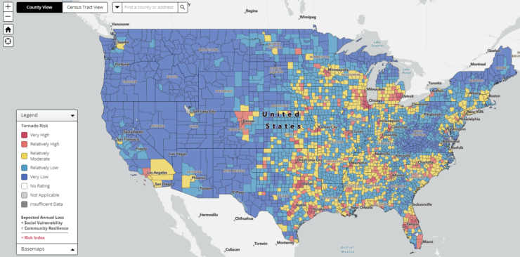
While tornadoes can occur in any state, they are most common in the central United States, an area often referred to as “Tornado Alley.” This region, which includes states like Texas, Oklahoma, and Kansas, sees a high concentration of tornadoes due to its unique geography and weather patterns.
However, the U.S. tornado threat shifts from the Southeast in the cooler months of the year, toward the southern and central Plains in May and June, and the northern Plains and Midwest during early summer.
The economic and human impact of tornadoes
Tornadoes can cause significant economic and human impacts. They can destroy homes and infrastructure, cause injuries and loss of life, and result in billions of dollars in damage.
The economic impact of tornadoes can be particularly severe in regions that are frequently hit by these storms, as the cost of recovery and rebuilding can be substantial.
Case study: The 2011 Joplin tornado
The 2011 Joplin tornado is a stark example of the devastating impact of tornadoes. On May 22, 2011, a catastrophic EF5-rated multiple-vortex tornado struck Joplin, Missouri, resulting in 158 deaths and over 1,000 injuries.
It was the deadliest tornado to hit the U.S. since 1947 and the seventh-deadliest in the nation’s history. The tornado caused damages amounting to $2.8 billion, making it the costliest single tornado in U.S. history.
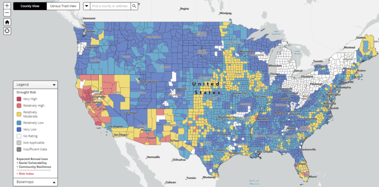
Droughts in the US: A Dry Spell
Droughts are natural disaster that can have severe impacts on both the environment and society. They occur when a region experiences a prolonged period of below-average precipitation, leading to a shortage of water.
In the United States, droughts are a common occurrence, affecting various parts of the country at different times and with varying severity.
Causes and Effects of Droughts
Droughts are primarily caused by a lack of rainfall over an extended period. This can be due to a variety of factors, including changes in atmospheric conditions, shifts in wind patterns, and even the effects of human activities such as deforestation and overuse of water resources.
The effects of droughts can be far-reaching. On the environmental side, they can lead to a loss of plant and animal life, increased soil erosion, and even changes in the landscape.
For humans, droughts can lead to water shortages, crop failures, and increased fire risk. They can also have significant economic impacts, affecting agriculture, energy production, and water supply industries.
Regions Most at Risk

The risk of drought varies across the United States, with some regions more prone to this natural disaster than others.
The western part of the country, including states like California, Nevada, and Arizona, is particularly susceptible to droughts due to its arid climate and reliance on seasonal rainfall.
The Great Plains region, known as the “Dust Bowl,” is also at high risk due to its heavy reliance on rain-fed agriculture.
The Economic and Environmental Impact
The economic impact of droughts in the US can be significant. According to the National Centers for Environmental Information, droughts have caused over $250 billion in damages in the US between 1980 and 2019. This makes them one of the most costly natural disasters in the country.
On the environmental side, droughts can lead to a range of negative impacts. These include reduced water quality, loss of wildlife habitat, increased soil erosion, and even permanent changes to ecosystems. Droughts can also contribute to other natural disasters, such as wildfires and heatwaves.
Case Study: The 2012-2017 California Drought
The 2012-2017 drought in California was one of the most severe in the state’s history. It led to significant water shortages, causing the state to implement strict water conservation measures.
The drought also had a major impact on the state’s agriculture industry, with crop losses estimated at $600 million in 2015 alone.
The California drought also had significant environmental impacts. It contributed to the death of millions of trees, increased wildfire risk, and caused widespread damage to wildlife habitats.
Despite the end of the drought in 2017, many of these impacts are still being felt today.
Landslides in the US: A Slippery Slope
Landslides are a common natural disaster in the United States, occurring in all 50 states. They are particularly prevalent in areas with steep slopes, loose rock, and heavy rainfall.
Landslides can be triggered by a variety of factors, including earthquakes, volcanic activity, changes in groundwater, and human activities such as deforestation and urban development.
The United States Geological Survey (USGS) estimates that landslides cause between 25 and 50 deaths annually in the US.
Causes and effects
Landslides occur when the stability of a slope is overcome by the force of gravity. This can happen due to a number of factors, including the steepness of the slope, the type of soil and rock present, the amount of water in the soil, and the weight of vegetation and structures on the slope.
The effects of landslides can be devastating. They can cause significant damage to infrastructure, including roads, bridges, and buildings. Landslides can also disrupt utilities and services, block transportation routes, and lead to economic losses.
In addition to the physical damage, landslides can also have a significant impact on the environment, causing loss of habitat, erosion, and water pollution.
Mapping landslide-prone regions in the US
The USGS has developed a National Landslide Hazards Map that identifies areas in the United States that are prone to landslides, like Washington state.
This map uses a combination of factors including slope, soil properties, rainfall, and seismic activity to determine landslide risk. The map is a valuable tool for land use planning and disaster preparedness.
The economic and human impact
Landslides have both a direct and indirect impact on the economy and human life. Direct costs of landslides include the damage to infrastructure, property, and loss of life.
Indirect costs can include lost productivity due to road closures, diversion of traffic, and long-term maintenance and repair of damaged land. The USGS estimates that landslides cause up to $2 billion in damages annually in the United States.
Case study: The 2014 Oso landslide
The Oso landslide, also known as the SR530 landslide, occurred in northwest Washington state on March 22, 2014. It was one of the deadliest landslides in U.S. history, resulting in 43 fatalities.
A portion of an unstable hill collapsed, sending mud and debris across the North Fork of the Stillaguamish River, engulfing a residential neighborhood, and covering approximately a square mile.
The landslide caused extensive damage to homes and infrastructure, including a highway. The total financial loss was estimated to be about $50 million, including emergency response, search and rescue, recovery, and rebuilding efforts.
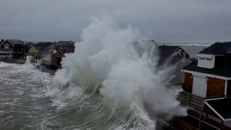
Tsunamis in the US: A Wave of Destruction
While tsunamis are not as common as other natural disasters in the United States, they pose a significant threat to coastal communities, particularly in the Pacific Ocean region.
Tsunamis are sea waves caused by underwater earthquakes, volcanic eruptions, or landslides. These waves can travel at high speeds across the ocean, causing widespread destruction when they reach the shore.
The science behind tsunamis
A tsunami is generated when there is a large displacement of water in the ocean or sea. This usually occurs due to seismic activity such as an underwater earthquake, where the sea floor abruptly deforms and vertically displaces the overlying water.
The energy released produces waves that travel across the ocean until they reach the coastline, where they can cause significant damage.
Tsunamis are not like regular waves. Instead of curling and breaking like a surf wave, a tsunami wave will often come ashore like a rapidly rising tide or a flood wave, which is why they are often referred to as tidal waves, even though they have nothing to do with tides.
Regions most vulnerable
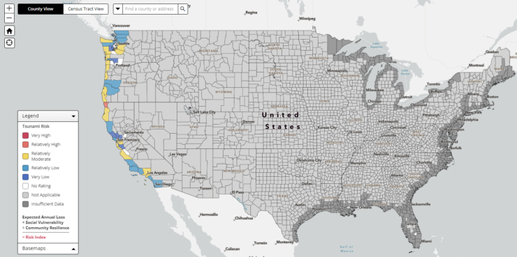
In the United States, the Pacific coastal regions are the most vulnerable to tsunamis, particularly Alaska, Washington, Oregon, and California.
This is due to the tectonic activity in the Pacific Ocean, specifically along the tectonic plate boundaries in the Pacific Ring of Fire. Hawaii is also at risk due to its location in the middle of the Pacific Ocean.
However, tsunamis can also affect other areas. The Atlantic coast, Gulf of Mexico, and even the Great Lakes have all experienced tsunamis, although they are much less common.
The economic and human impact
The impact of a tsunami can be devastating. They can cause loss of life, destroy homes and infrastructure, and lead to significant economic losses.
The cost of rebuilding after a tsunami can be enormous, and the impact on local economies can be felt for years after the event.
In addition to the physical destruction, tsunamis can also have a significant psychological impact on those affected. The trauma of the event can lead to long-term mental health issues, including post-traumatic stress disorder (PTSD).
Case study: The 1964 Alaska earthquake and tsunami
The 1964 Alaska earthquake, also known as the Great Alaskan earthquake, is a prime example of the destructive power of tsunamis.
The earthquake, which had a magnitude of 9.2, was the most powerful recorded in North American history and the second most powerful recorded worldwide.
The earthquake triggered a series of tsunamis that caused extensive damage along the west coast of the United States, as far away as California and Hawaii, and even as far as Japan.
In total, the tsunamis claimed about 130 lives and caused an estimated $2.3 billion in property loss (in 2020 dollars).
Volcanic Eruptions in the US: A Fiery Threat
Volcanic activity is a significant part of the geological landscape of the United States. With over 160 active volcanoes, the US ranks as one of the top countries in the world for the number of volcanoes within its borders.
These volcanoes are scattered across the country, with a significant concentration in the western states, particularly Alaska, Hawaii, California, Oregon, and Washington.
The science behind volcanic eruptions
Volcanic eruptions occur when there is a release of magma, gas, and other materials from beneath the Earth’s surface.
This release is usually caused by the movement of tectonic plates, which can create pressure and heat that melts rock into magma. When the pressure becomes too great, an eruption occurs.
There are different types of volcanic eruptions, ranging from effusive eruptions, where lava slowly oozes out of the volcano, to explosive eruptions, where there is a violent release of gas and volcanic material.
The type of eruption depends on the composition of the magma and the amount of gas it contains.
Mapping volcano-prone regions in the US
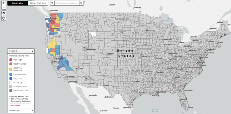
The United States Geological Survey (USGS) maintains a comprehensive database of the country’s volcanoes and their activity levels.
The most volcanically active regions in the US are Alaska, which has over 50 active volcanoes, and Hawaii, home to some of the world’s most active volcanoes, including Kilauea and Mauna Loa.
The Pacific Northwest is also home to several active volcanoes, including Mount St. Helens and Mount Rainier in Washington, and Mount Hood in Oregon. California has a number of active volcanoes as well, including Mount Shasta and the Long Valley Caldera.
The economic and human impact
Volcanic eruptions can have significant economic and human impacts. They can cause loss of life and property, disrupt transportation and communication networks, and lead to long-term environmental changes.
The ash and gases released during an eruption can also have health impacts, including respiratory problems and other illnesses.
The economic cost of a volcanic eruption can be substantial. This includes the immediate costs of evacuation and emergency response, as well as the longer-term costs of rebuilding and recovery. There can also be significant economic losses from disruption to agriculture, tourism, and other industries.
Case study: The 1980 Mount St. Helens eruption
The eruption of Mount St. Helens in Washington state in 1980 is one of the most well-known volcanic eruptions in US history.
The eruption, which was triggered by a magnitude 5.1 earthquake, resulted in the deadliest and most economically destructive volcanic event in the history of the United States.
The eruption caused the deaths of 57 people and caused over a billion dollars in damage. It also resulted in significant environmental changes, including the destruction of hundreds of square miles of forest.
Hazard Mitigation Planning: Breaking the Cycle of Disaster Damage and Reconstruction
Hazard mitigation planning is the process of identifying risks and vulnerabilities associated with natural disasters and developing strategies to reduce these risks.
This is a proactive approach, aimed at reducing the loss of life and property damage from future disasters, rather than simply responding to disasters after they occur.
The process of identifying natural disaster risks and vulnerabilities
Hazard mitigation planning begins with state, tribal, and local governments identifying natural disaster risks and vulnerabilities that are common in their area.
This involves understanding the types of natural disasters that a region is prone to, the frequency and intensity of these disasters, and the potential impacts of these disasters.
This also includes identifying the populations, structures, and systems that are most vulnerable to these disasters. This process often involves a combination of historical data analysis, scientific modeling, and community input.
The Role of State, tribal, and local governments in hazard mitigation planning
State, tribal, and local governments play a crucial role in hazard mitigation planning. They are responsible for developing and implementing hazard mitigation plans that reflect the unique risks and vulnerabilities of their communities.
These plans outline long-term strategies for protecting people and property from similar events. They may include measures such as land use planning, building code enforcement, public education, and infrastructure improvements.
These governments are also responsible for coordinating with other levels of government, as well as with the private sector and non-profit organizations, to implement these plans.
Case Study: A successful hazard mitigation plan in Action
One example of a successful hazard mitigation plan is the one implemented by the city of Tulsa, Oklahoma. After experiencing repeated flooding in the 1970s and 1980s, the city developed a comprehensive floodplain management plan.
This plan included measures such as stricter building codes, the creation of a stormwater management department, and the relocation of homes and businesses out of the floodplain.
As a result of these efforts, the city has significantly reduced its vulnerability to flooding and has saved millions of dollars in potential flood damage.
Epilogue
Natural disasters are an undeniable part of life in the United States. From earthquakes in California to hurricanes in Florida, from wildfires in the West to tornadoes in the Midwest, these events shape our landscapes and our lives.
Yet, while we cannot prevent these disasters, we can prepare for them.
By understanding the science behind these events, identifying the regions most vulnerable to them, and studying the economic and human impacts of past disasters, we can better equip ourselves to face these challenges.